A Case Study October 2022.
Project Location: Glanmire Village, Cork City.
Area of Land: 2.5 Acres set in a heavily wooded site.
Mission: To Prepare Accurate Land Registry Compliant Maps to enable the separate sale of 4 No Apartments, 2 No cottages, the remainder of the site would be transferred to my client’s son with the exception of a site for my client.
NB* The owner required the mapping work carried out quickly and accurately while prioritising the sale of the Apartments, which would enable funding for the rest of the project.
Comments from Our Client:
We are in the process of selling several properties all adjacent to our home in Glanmire, Cork Our solicitor informed me that we needed the maps for the property updated to prepare for the sale.
They consist of 4 apartments and 2 cottages. Part of this downsizing process also involves transferring our current home to one of my sons and building a new home in the grounds of the property.
As the apartments are now designated as ‘muti story’ even though only on two floors the mapping of all the separate dwellings in the overall property was complicated. We were recommended to use the services of Baseline Surveys by our architect. This proved a very instructive process and to me, a layman in this area, very complicated.
However the very professional input and advise given by Mr Paudie Barry of Baseline managed to manoeuvre us though the quagmire.
All of the liaisons with the ordinance survey, land registry and my solicitor was dealt with in a very clear and thorough manner by Baseline.
We can highly recommend their service to any who may require it, as we were totally satisfied with the final outcome.
Yours sincerely
Noel May
Introduction
Our first priority was to establish if the current OSi map features matched up with the actual position of the overall site boundary and the proposed internal division lines. These site boundary features were surveyed with a blend of GPS and Total Station readings on site in order to check the veracity of the current OSi Map for the area.
As the current OSi map forms the base map for any land registry submission, it was important for us to overlay our topographical survey results to verify that the critical boundary features were in fact mapped correctly by the Ordnance Survey prior to creating our Land Registry Compliant Maps.
In other words, because we are procedurally restricted under the new 2021 PRAI Mapping Rules to using OSi map features (where available) for Land Registry submission, we needed to be sure that the OSi Map features we were going to trace, for our various Land Registry Subdivision Maps, were in fact correct by surveying them with GPS.
Multi story Property Registration
The stated tolerance for Ordnance Survey (OSi) Mapping is +/-1m. The OSi Map was within tolerance for this project. As it turned out we didn’t need to ask the OSi to visit the site to correct their map feature positions, so we could proceed immediately with preparing the Multi Story Mapping element for the Apartments.
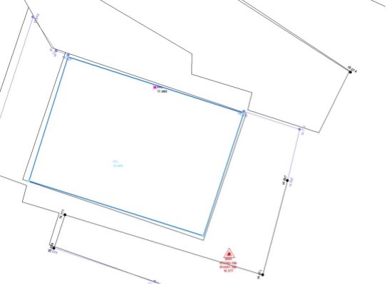
The Grey OSi Map is out by 0.4m from the Blue Topo Survey, which is inside the OSi Map tolerance of +/-1m.
The new 2021 rules for Multi story Registration under Appendix 5a call for a location map and floor plans to be submitted. Sufficient accuracy is required to convey ownership of the paint but not the ceiling or the walls. Each apartment has its own garden.
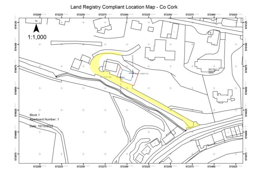
Land Registry Compliant Multi Story Registration Location Map
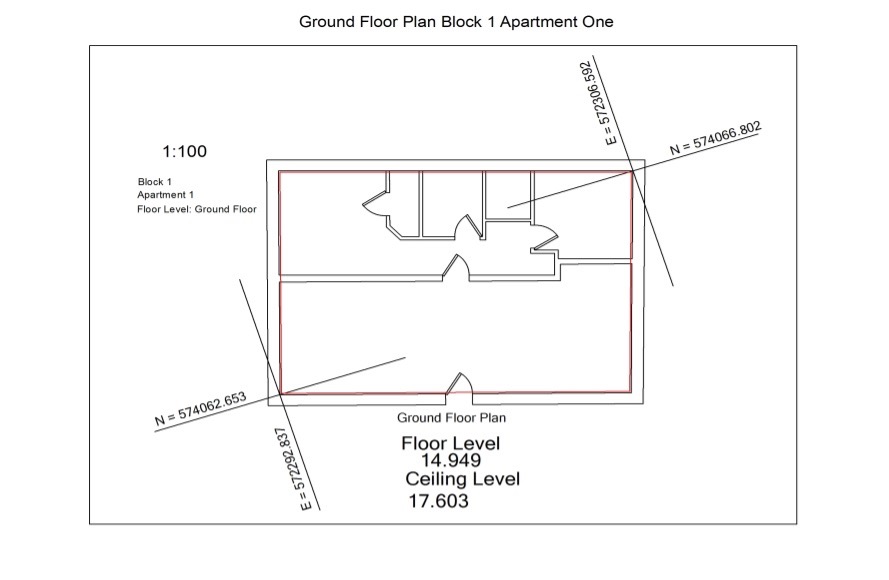
Land Registry Compliant Multi Story Registration Floor Plan
Of the 4 No Apartment Blocks the 2No first floor apartments were being sold off with their attic spaces, so the maps had to convey ownership from floor level to the sloping ceilings. All apartments have garden spaces and a Right of Way which also had to be mapped.
2D PRAI Registration
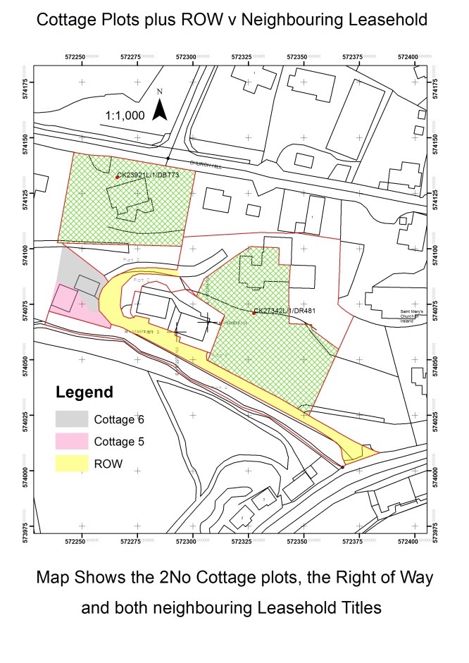
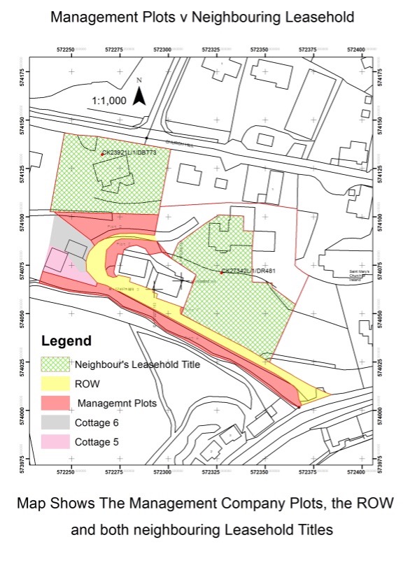
Once we completed the Multi Story Registration maps we moved onto the 2D mapping of the plots for each of the 2No cottages. Both Cottages bounded the overall site boundary to the west and to the north of the second cottage. To the west lay unregistered land, with the boundary defined as a line of concrete posts, which we surveyed on site using a laser. The neighbouring Leasehold title CK23921L bounds the site to the north of the second cottage, which we ordered in digital format from the PRAI, so we could precisely butt against it in CAD with our own boundary. The Right of Way, shaded yellow below, also required the same treatment with respect to Leasehold folio CK27342L along with the two cottage plots.
The cottage entrances were separated by a concrete planter, which served a dual purpose; as a traffic island and as a boundary feature being split in half. The planter was surveyed on site using GPS. Once accurately outlined to the satisfaction of our client, both plots were emailed to the Spatial Information Unit requesting an S number and a unique ID for each of the two plots. The PRAI then thoroughly check the digital polygons for conflict, if there is no clash then the geometry is guaranteed to be accepted and an S number is issued. Many polygons may be defined under the one S number, but require a unique ID for each plot.
Once we had defined the geometry for overall site curtilage, the Right of Way and the two cottage plots we could then define the geometry for the areas which would fall under the control of the management company. Again, an accurate CAD outline was established and S numbers and unique IDs were requested to sharply define the geometry for the assignment of plots to the management company.
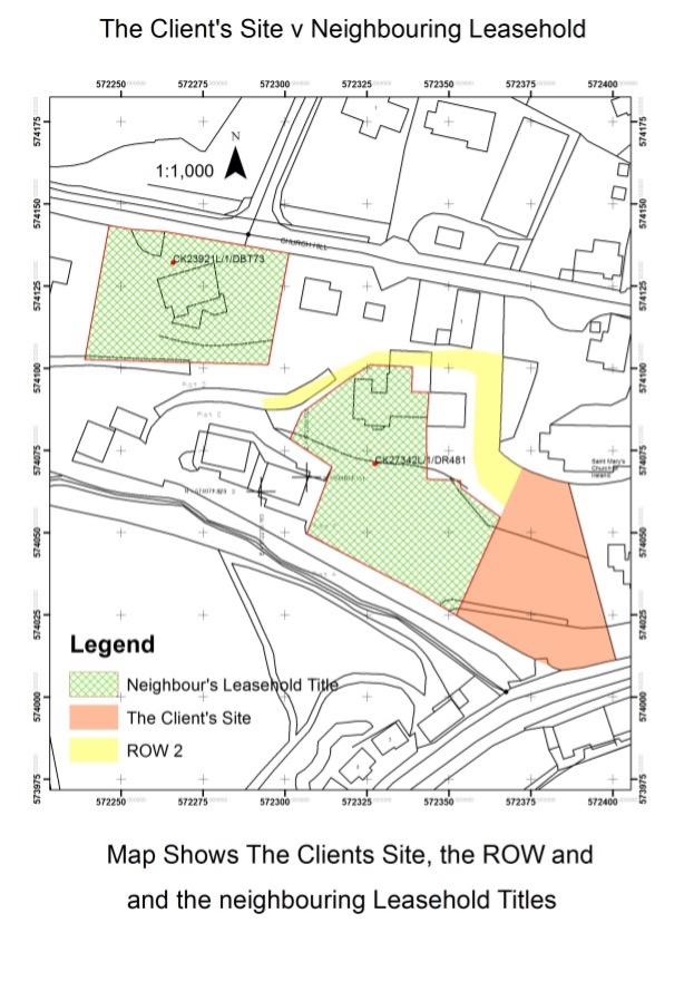
The next plot to map was the site for my client, where he has planning permission to build his home. We also needed to map a second Right of Way to continue on from the first right of way. An S Number with a unique ID was applied for and acquired for my client’s own site and his ROW from the PRAI. We butted the ownership line up against the neighbouring leasehold title CK27342L. As we checked the OSi boundary lines with GPS we were satisfied with their accuracy enough use them to define the ownership geometry.
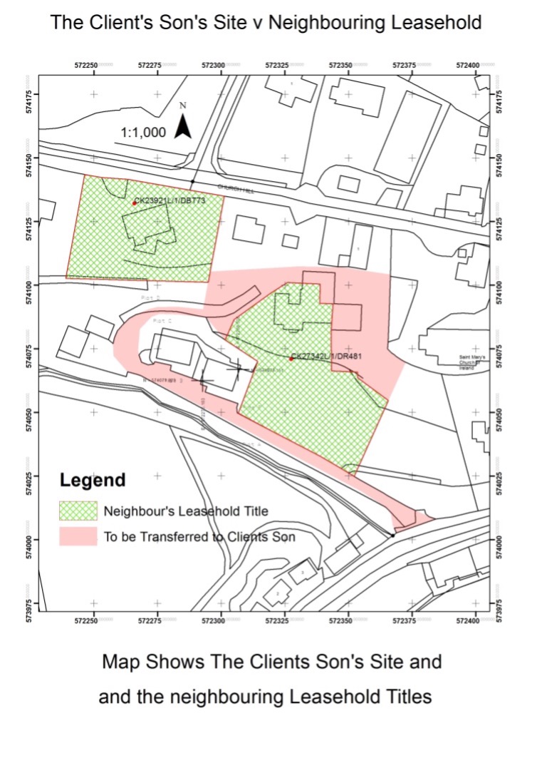
All that was remaining to complete from our initial specification was to map the plot that was going to be transferred to my Client’s Son. The geometry is defined by an S number with a unique ID for this last plot.
Land Swap Transfer Mapping
During the process, as we physically surveyed the actual boundary with GPS and a total station, we discovered an error in CK27342L, the neighbouring leasehold title map. The physical 2m high post and wire fence bounding the neighbour’s leasehold title was not located accurately on the leasehold title map as shown below:
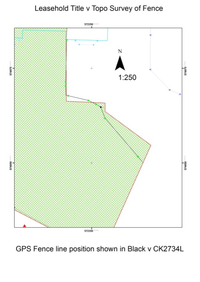
As you can see from the map above the fence line is misaligned with the existing fence. I advised my client of this and I suggested we fix the mapping to match the ground. My Client was happy with that approach. We requested an S number with unique IDs for this area by emailing both polygons that correct the mapping error. We created 2 maps, one map to give away the plot outside of my clients occupation and a second Land registry compliant map showing the plot inside my clients occupation but also within CK2734L.
Results:
The geometry for all the various plots were submitted and confirmed by the PRAI to be conflict free and the boundaries are all defined to the nearest millimetre.
As the Land Registry issued S Numbers/unique IDs for all the various plots, it means that my land registry compliant maps are guaranteed to be accepted by the PRAI.
About Baseline Survey Ltd
Paudie Barry, Company Owner, is a spatial data specialist, a qualified Civil Engineer, has a Higher Diploma in GIS and 33 years of experience as a Land Surveyor.
My 33 years as a land surveyor enables me to deal with the Ordnance Survey Quality Assurance department and my Higher Diploma in Geographic Information Systems enables me to communicate effectively with the Spatial Information Unit in Land Registry in order to resolve incorrect mapping or to accurately register a new plot.

Please feel free to contact me with any Land Registry Mapping query you may have.
Paudie Barry 086 2535285
CONTACT BASELINE SURVEYS TODAY FOR A FREE CONSULTATION
We are available now and we have a very fast turnaround time.
Paudie would be delighted to discuss your legal mapping services
Or email: paudie@baselinesurveys.ie
