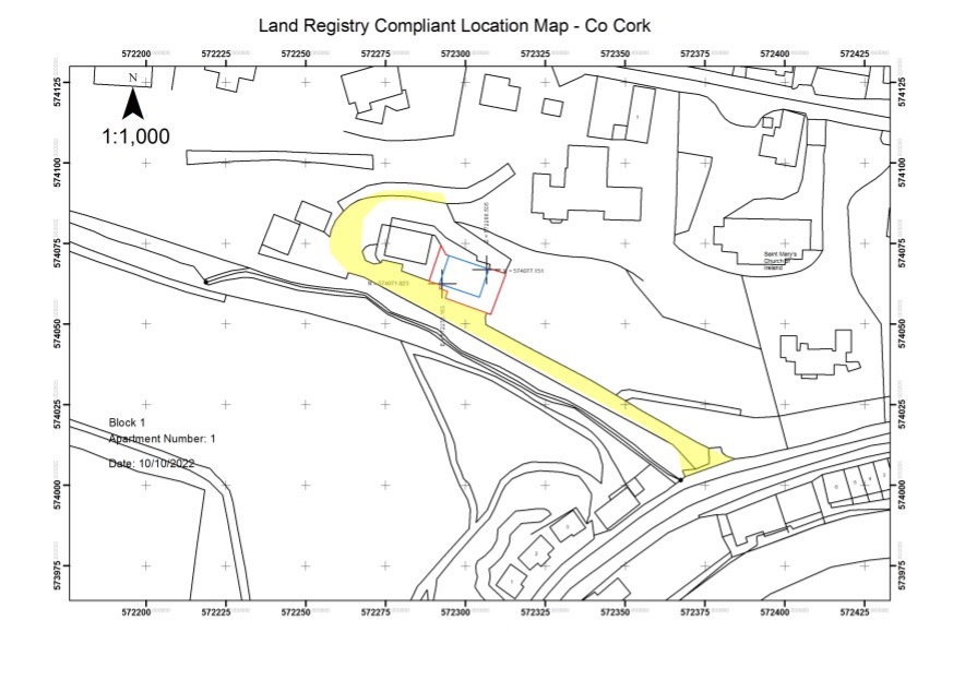
denis.finnegan@grofuse.com

About denis.finnegan@grofuse.com

This author has not yet filled in any details.
So far denis.finnegan@grofuse.com has created 9 blog entries.

Land Registry Compliant Multi Story, Subdivision and Rectification Mapping – Case Study

Case Study: To Prepare Accurate Land Registry Compliant Maps to enable the separate sale of 4 No Apartments, 2 No cottages, the remainder of the site would be transferred to my client’s son with the exception of a site for my client.

By |2022-10-14T10:23:34+01:0013 October 2022|Case Studies, News & Insights|Comments Off on Land Registry Compliant Multi Story, Subdivision and Rectification Mapping – Case Study

Sub Millimetre Setting Out & Surveying by Baseline Surveys Ltd

There are a number of critical components to being able to produce extremely accurate setting out or surveying. The most important component is being fully relaxed and focused, because of this it’s important to reduce the amount of environmental distractions as much as possible and to fully ignore everything except what you are doing.

By |2022-10-13T08:49:04+01:0013 October 2022|News & Insights|Comments Off on Sub Millimetre Setting Out & Surveying by Baseline Surveys Ltd

How Engineers can Avoid Embarrassing Land Registry Malfunctions

I will be examining the problematic and very common practice of transferring land by submitting paper maps to Land Registry and how it can go terribly wrong when a planning permission application is made on the same plot of land and what you can do to avoid disaster. The solution is surprisingly simple.

By |2022-10-13T09:03:21+01:0013 September 2022|News & Insights|Comments Off on How Engineers can Avoid Embarrassing Land Registry Malfunctions

RPAS case study: Dun Laoghaire Harbour topographic survey

Baseline Surveys is a company with 25 years of experience in the supply of highly accurate geospatial data, such as cadastral, topographic and engineering surveys to commercial and government bodies. Baseline was awarded a contract to survey approximately 1 km2 of Ireland's Dun Laoghaire town centre and harbour area for the purpose of providing a topographic survey for a detailed engineering redesign of the existing port.

By |2021-09-08T19:55:16+01:0019 August 2021|News & Insights|Comments Off on RPAS case study: Dun Laoghaire Harbour topographic survey

Forest Inventory Article

Baseline Surveys pioneered the use of unmanned aerial vehicles (UAVs) to photograph and map standing crops of trees to an astonishing degree of accuracy. In many respects, this technology is complementary to, rather than in competition with, Treemetrics.

By |2021-09-08T20:00:27+01:0019 August 2021|News & Insights|Comments Off on Forest Inventory Article
Go to Top